File:Jewish land possession 1944 with 1949 armistice outline.png
Original file (2,000 × 3,616 pixels, file size: 8.05 MB, MIME type: image/png)
Description
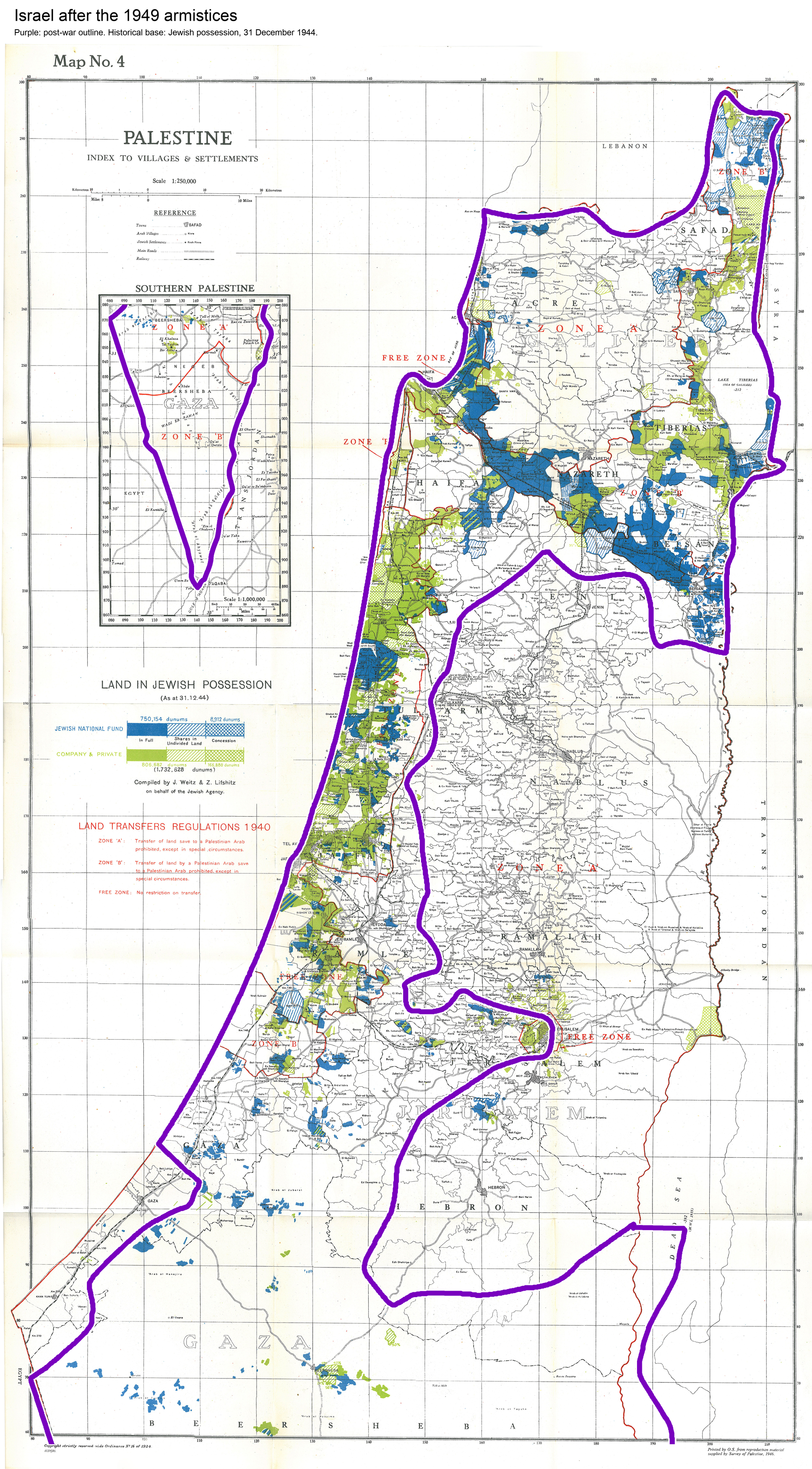
Jewish land in possession on 31 December 1944, with the post-war Israeli-held area outlined in purple according to the 1949–1950 armistice lines. The southern Negev is shown in the original inset. The original red lines identify the 1940 Land Transfers Regulations; they are not state boundaries.
The underlying map is the original 1944 possession scan, compiled by J. Weitz and Z. Lifshitz for the Jewish Agency and printed by the Ordnance Survey from Survey of Palestine material in 1946. Its holdings, labels and colours are retained.
Boundary sources
- AnonMoos and Wikimedia Commons contributors, 1947 UN Partition Plan / 1949 Armistice comparison, public-domain vector map first published in 2007, current SVG revision dated 8 November 2013. The corrected boundary through the Dead Sea is retained.
- United Nations, Map No. 761, November 1955, showing the armistice agreements between Israel and Lebanon, Syria, Jordan and Egypt. The vector geometry was registered to this map and fitted to the possession map through the printed Palestine-grid coordinates.
This is a generalized historical overview. Small demilitarized zones, no-man’s-land and the detailed Jerusalem enclaves require larger-scale treaty maps; the overview does not resolve those details. Its outline is not used to calculate ownership percentages, which come from the separately cited statistical tables. The 1944 possession data have not been relabelled as 1949 ownership.
Licensing
The 1946 British government base map is in the public domain. The source vector was released into the public domain by AnonMoos. The added heading, registration and outline layer are released under CC0.
File history
Click on a date/time to view the file as it appeared at that time.
| Date/Time | Thumbnail | Dimensions | User | Comment | |
|---|---|---|---|---|---|
| current | 22:50, 12 November 2026 | | 2,000 × 3,616 (8.05 MB) | Quill (talk | contribs) | Add a source-based 1949 armistice outline over the unchanged 1944 possession map, with provenance and scale limits. |
You cannot overwrite this file.
Links
The following pages link to this file: